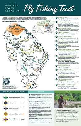
top of page
15 Fishing Spots

Below are 15 fishing spots along the Western North Carolina Fly Fishing Trail, complete with GPS coordinates.

Please note: These coordinates direct folks to the general vicinity of each fishing spot. They aren't designed to be specific fishing locations. Accuracy is measured in yards.

These are not "hot spots."  As always, respect property owners' rights and avoid posted land. 

WNC FlyFishing Trail 2022_Page_1.jpg

1. SCOTT CREEK

N 35° 18.816, W 083° 07.588 Elevation - 2,685 feet (recorded @ Willets Community, mouth of North Fork) Also 35? 24’ 14.31” N, 83? 10’52.28” W

The Stretch: Roughly 10 miles from headwaters near Balsam down to Sylva

Access Point(s): Parking and access available via several pull-off areas along U.S. 23/74

Type of Water: Hatchery Supported

Available Fish: Brown, Rainbow

Numbers or Size?: Numbers

Noteworthy: Stretch also includes North Fork Scott Creek and Buff Creek, which are very scenic

2. SMALL STREAMS

N 35° 18.816, W 083° 07.566 Elevation - 2,209 feet

Moses Creek, Mull Creek, Rough Butt Creek, Chastine Creek, Piney Mountain Creek

The Stretch: Collection of small streams in eastern Jackson County, below Blue Ridge Parkway

Access Point(s): Via Moses Creek Rd (SR 1740) & Caney Fork Rd (SR 1737), avoid posted land

Type of Water: Wild Trout

Available Fish: Brook, Rainbow

Numbers or Size?: Numbers

Noteworthy: Mountainous terrain, includes several large waterfalls

3. CANEY FORK

N 35° 18.816, W 083° 04.031 Elevation - 2,542 feet

The Stretch: Roughly 10 miles from East Laporte Park to headwaters at fork of Mull Creek and Piney Mountain Creek

Access Point(s): Access via Caney Fork Road (SR 1737), avoid posted land

Type of Water: Undesignated

Available Fish: Rainbow, Brown, occasional Brook

Numbers or Size?: Numbers

Noteworthy: Respect private land owners

4. TANASEE CREEK

N 35° 12.942, W 082° 59.199 Elevation - 3,110 feet (recorded @ Tanasee Creek bridge)

The Stretch: Roughly 2-3 miles from Tanasee Creek bridge up to headwaters

Access Point(s): Parking and access available at bridge on Tanasee Creek Road (SR 1762)

Type of Water: Wild Trout

Available Fish: Brown

Numbers or Size?: Both

Noteworthy: Very scenic stretch in the Nantahala National Forest

5. PANTHERTOWN CREEK

N 35° 10.077, W 083° 02.391 Elevation - 4,123 feet (recorded @ trail head off Breedlove Road)

The Stretch: Entire stream, roughly 3 miles

Access Point(s): Parking and access at end of Breedlove Rd (SR 1121), with 2-mile walk to creek

Type of Water: Catch & Release Single Hook Artificial Lure

Available Fish: Brook

Numbers or Size?: Numbers

Noteworthy: Located in Panthertown Valley, which is known as the “Yosemite of the East” because of its bowl shape and rocky bluffs

6. RAVEN FORK (Cherokee Trophy Water)

N 35°30'21", W 083°18'1" Elevation - 2,000 feet (recorded @ Blue Ridge Parkway bridge)

The Stretch: Starts at Blue Ridge Parkway bridge near Cherokee and goes north for 2.2 miles

Access Point(s): Parking & access via several pull-off areas along Big Cove Road; paths run along stream

Type of Water: Catch & Release Fly Fishing Only

Available Fish: Golden, Rainbow, Brown, Brook & Donaldson trout

Numbers or Size?: Both 
Noteworthy: This stretch is also called Cherokee Trophy Water and fish of 20-30 inches are common; Cherokee annual permit and daily permit required

7. WHITEWATER RIVER

N 35° 03.973, W 083° 03.935 Elevation - 3,544 feet (recorded @ Silver Run Falls, headwaters of the Whitewater River)

The Stretch: Roughly 2-3 miles from Hwy. 107 down to the South Carolina state line

Access Point(s): Parking and access along N.C. 107, a few miles south of Cashiers

Type of Water: Wild Trout

Available Fish: Brook, Brown and Rainbow

Numbers or Size?: Numbers

Noteworthy: Flows into Whitewater Falls, the highest waterfall east of the Mississippi

8. SCOTSMAN and FOWLER CREEKS into CHATTOOGA RIVER

N 35° 01.380, W 083° 05.738 Elevation - 2,705 feet (recorded @ small parking area off Bullpen Road in national forest)

The Stretch: Roughly 2-3 miles of each stream flowing down into the ChattoogaRiver

Access Point(s): Access available via Whiteside Cove Rd (SR 1107) or Bullpen Rd (SR 1100) in Nantahala National Forest

Type of Water: Wild Trout with Natural Bait

Available Fish: Brown, Rainbow

Numbers or Size?: Numbers (creeks), Size (Chattooga)

Noteworthy: The movie Deliverance was filmed on the Chattooga River

9. WEST FORK TUCKASEIGEE RIVER

N 35° 14.080, W 083° 07.433 Elevation - 2,312 feet (recorded @ pull-off near Thorpe Power House)

The Stretch: From small reservoir at Thorpe Power House upstream several hundred yards

Access Point(s): Parking and access available both sides of N.C. 107 near Thorpe Power House

Type of Water: Hatchery Supported

Available Fish: Brown, Rainbow

Numbers or Size?: Numbers

Noteworthy: Although hatchery supported, this has nice concentration of stream-raised fish

10. TUCKASEIGEE RIVER (East LaPorte Park to NC 107 Bridge)

N 35° 17.866, W 083° 07.433 Elevation - 2,155 feet Also 35? 17” 49.99” N, 83? 8’42.63” W

The Stretch: Roughly 2-3 miles from park to bridge

Access Point(s): Parking and access available at East Laporte Park and pull-off areas along Old Cullowhee Road

Type of Water: Hatchery Supported

Available Fish: Rainbow, Brook and Brown

Numbers or Size?: Numbers

Noteworthy: East Laporte Park has picnic tables and public restrooms

11. SAVANNAH CREEK

N 35° 19.390, W 083° 15.682 Elevation - 2,216 feet

The Stretch: About 10 miles from headwaters in Pumpkintown into Tuckaseigee River

Access Point(s): Parking and access available via several pull-offs along U.S. 23/441
Type of Water: Hatchery Supported

Available Fish: Rainbow, Brown

Numbers or Size?: Numbers

Noteworthy: Access limited the closer you get to the Tuckasegee River

12. TUCKASEIGEE RIVER (NC 107 Bridge to Dillsboro park)

N 35° 20.489, W 083° 12.125 Elevation - 2,073 feet (recorded @ first pull-off on South River Road, coming from 107)

The Stretch: Roughly 4-5 mile stretch from bridge to the riverside park in Dillsboro
Access Point(s): Parking and access available via numerous pull-offs along North River Road

Type of Water: Delayed Harvest

Available Fish: Brook, Brown and Rainbow

Numbers or Size?: Both

Noteworthy: Best place to achieve the Tuckaseigee Slam (catch all three species in one spot)

13. GREENS CREEK

N 35° 19.716, W 083° 15.746 Elevation - 2,173 feet (recorded @ Greens Creek Road)

 The Stretch: About 3-4 miles from Macon County line to Savannah Creek

Access Point(s): Various places along Greens Creek Road (SR 1370)

Types of Water: Wild Trout, Undesignated, Hatchery Supported

Available Fish: Rainbow, some Brown

Numbers or Size?: Numbers

Noteworthy: Portion of the creek flows through the Nantahala National Forest

14. TUCKASEIGEE RIVER (in Dillsboro)

N 35° 22.070, W 083° 15.149 Elevation - 2,005 feet (recorded @ Dillsboro Park)

The Stretch: About 1 mile from Dillsboro park through town

Access Point(s): Various places between park and Best Western River Escape Inn

Type of Water: Hatchery Supported

Available Fish: Rainbow, Brown

Numbers or Size?: Size

Noteworthy: Includes two lodging options: Best Western River Escape Inn and Dillsboro Inn

15. LOWER TUCKASEIGEE RIVER (Barker’s Creek Bridge to Whittier)

N 35° 23.064, W 083° 17.543 Elevation - 1,951 feet (recorded @ Barkers Creek Bridge)

The Stretch: Roughly 8-10 miles from bridge to Whittier

Access Point(s): Parking and access via pull-offs and businesses along U.S. 19/74 freeway

Type of Water: Hatchery Supported, Undesignated

Available Fish: Rainbow, Brown

Numbers or Size?: Size

Noteworthy: The stretch is also home to smallmouth bass

Please reload

bottom of page